


«12. . .212213214215216217218. . .2,6482,649»

Oops! I forgot that Ransium would be absent for some time. It's good, though, he should enjoy his vacation and come back refreshed. ^_^
Yay! Shalotte!
Yes, that is doable. I don't know whether I'll get to it this week or in the next update, but I do see a couple of ways I could make Caracasus coastal.
Precisely. I'm purposefully avoiding any reference to specific latitudes or climates. You could imagine an equator anywhere on there -- upper, middle, lower -- or a polar circle, even. I also tried to avoid land forms that give a sense of a specific scale, so anyone can imagine their nation as large, small, cold, hot, humid, arid, ...whatever they wish. (I will probably add a "scale" to the map but it will be purely decorative and won't specify what units the numbers refer to.)
It's been well over two years since a map included Dawn Tiger Straits (never labeled in the singular). Without being told to revert to that old name specifically, I opted for a transitional layout between the two forms it has appeared as in the past (a sea and a long vertical string of straits). I went with a gulf and some shorter straits to the north. With the gulf being a substantial body of water that can accommodate a prominent label, it was the natural choice. However, we can just as well consider the small straits further north to be named Dawn Tiger Straits, but as yet unlabeled. I may label smaller water features as time goes on, but it will be from the top down (larger bodies first). For now there aren't enough names to go around, but that shouldn't limit our imaginations.
Gil zardon, Frieden-und Freudenland, and Canaltia
Good observation! I always interpreted the map as a local (because there is unexplored wilderness) map of the ntohern hemisphere. Thanks for pointing out my prejudices :) For RP reasons i'll stick to my interpretation. But well put!
Caracasus, Frieden-und Freudenland, and Canaltia
Just saw that I was mentioned here.. what was it about?
Thank you! As I said, if it's too much bother, please don't worry about it.

Thank you,  Mozworld.
I'm cool with it, Gil zardon and Bruination - just swap with me ^^
Gil zardon, Frieden-und Freudenland, Bruination, and Canaltia
It looks like California has survived.
Gro-environment, Frieden-und Freudenland, Bruination, Ventus aeternam, and 1 otherCanaltia
Are we going to reestablish our embassy with California?
If they recover...
The restored delegate hasn't realised they've regained control just yet, but once they do and they kick out the rest of the raiders (particularly the one who has embassy control) then yeah we could reestablish the embassy. I think technically speaking they'll only have 3 WA members after everyone has left but I think we should give them the benefit of the doubt and reopen the embassy anyway.
Esterild, Frieden-und Freudenland, Ventus aeternam, and Canaltia
I think so, too. 3 WA members shouldn't be a problem, because there is a special circumstance here.
Sure, Forest would doubtlessly hope for the same treatment if our situations would reverse!
*were, even.
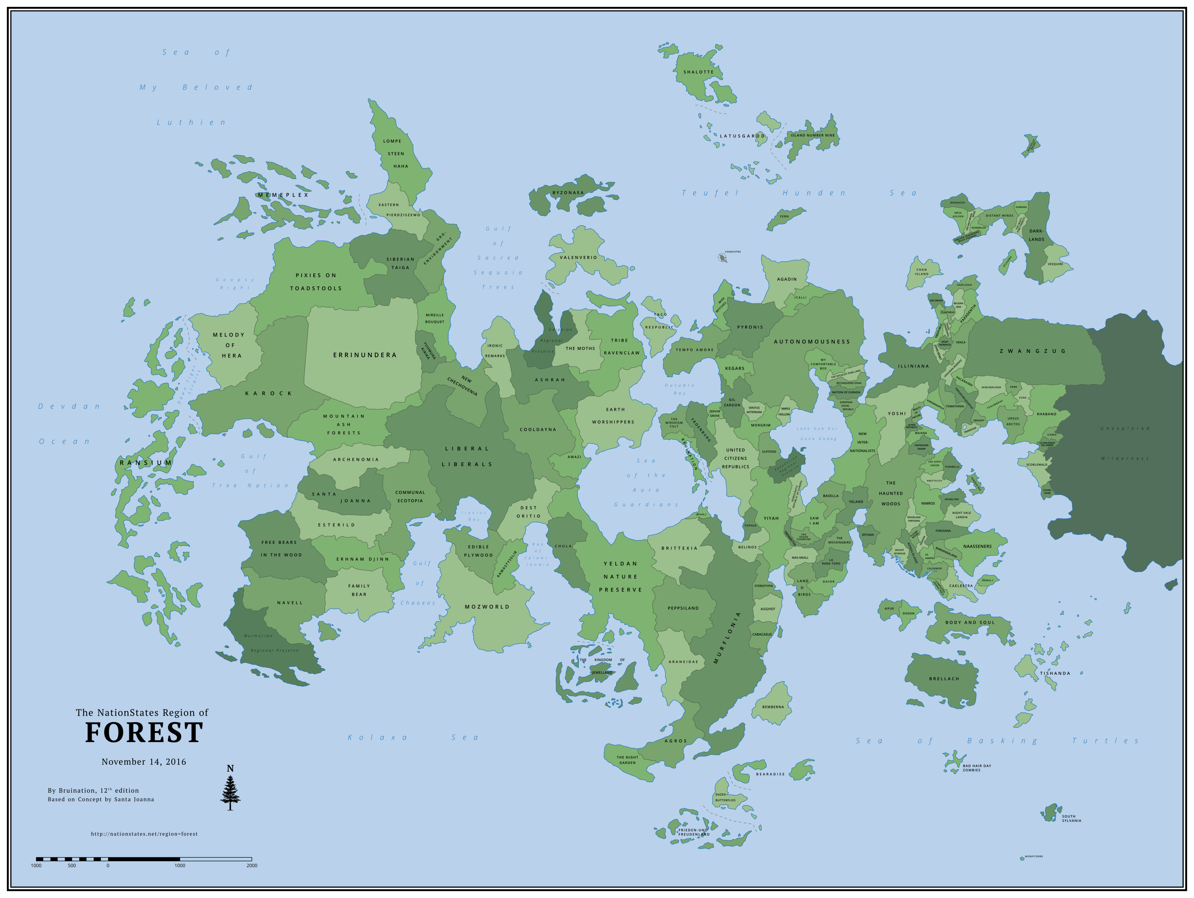
I finished the new map and wrote a new dispatch to serve as the one-stop place for all map information and links:
NOTE: Before asking questions about the map, please read the entire section below titled How to Get on the Map. If you don't find answers to your questions here, please telegram the cartographer, Bruination, instead of asking on the regional message board (RMB).
Introduction Forest's regional map is one of the largest on NationStates and differs from most in a few key ways. It is not an opt-in map on which nations must request inclusion. Nations are automatically added as long as they meet certain criteria based on the nation's participation in the region. Forest's map has two main functions: Firstly, it uniquely serves as a timeline of when each nation first arrived in Forest, with the earliest arrivals positioned to the west and the latest to the east. Secondly, it illustrates every nation's relative population, with more populous nations occupying more land area. The land and coastline evolve with each new update, as nations arrive, grow, or depart. The map is not primarily a role-play tool, although it can be used as one.
The original map series of Forest was begun by Santa Joanna in February 2012 and continued until September 2014. After a year with no further updates, Bruination began work on reviving the regional map with a new layout and style, while honoring the traditions set by Santa Joanna of using the map as both a timeline and a representation of population size. The first edition of Bruination's series was released in November 2015. By June 2016, the map had grown to depict 151 nations, the highest number on any known regional map on NationStates at the time. |
Contents |
Changes in This Edition:
Added (18)
Arbb, The misty pine forests, Euna, Purabella, Tishanda, Rhabano, Eumangi, Scorlewald, Monpiterre, Nouvelle bouef, Darklands, Le parlement des arbres, Vesquire, South sylvania, Bondaisia, Hazelonia, Cosireshire, IcareaExpanded (21)
Mount Seymour, Prettycity, Woodland partisans, Wise Witches, Nimros, Mireille bouquet, Stereotypia, Okefenokee swamp, Peppsiland, Ulfstead, Belgianadia, Eryndlynd, Gil zardon, Mag meall, Terumbrae, Agadin, Democratic republic of europa, Tempo amore, Aengloland, Chan island, The MothsRemoved (11)
Delionera, Oecos, Shilmesta, New Lvsitania, Idryll, Lebowskiberg, Walquiria, Leafapolis, Nonus The Hobo, Crasterram, ElfendelTotal Nations: 171
Previous Edition: 164
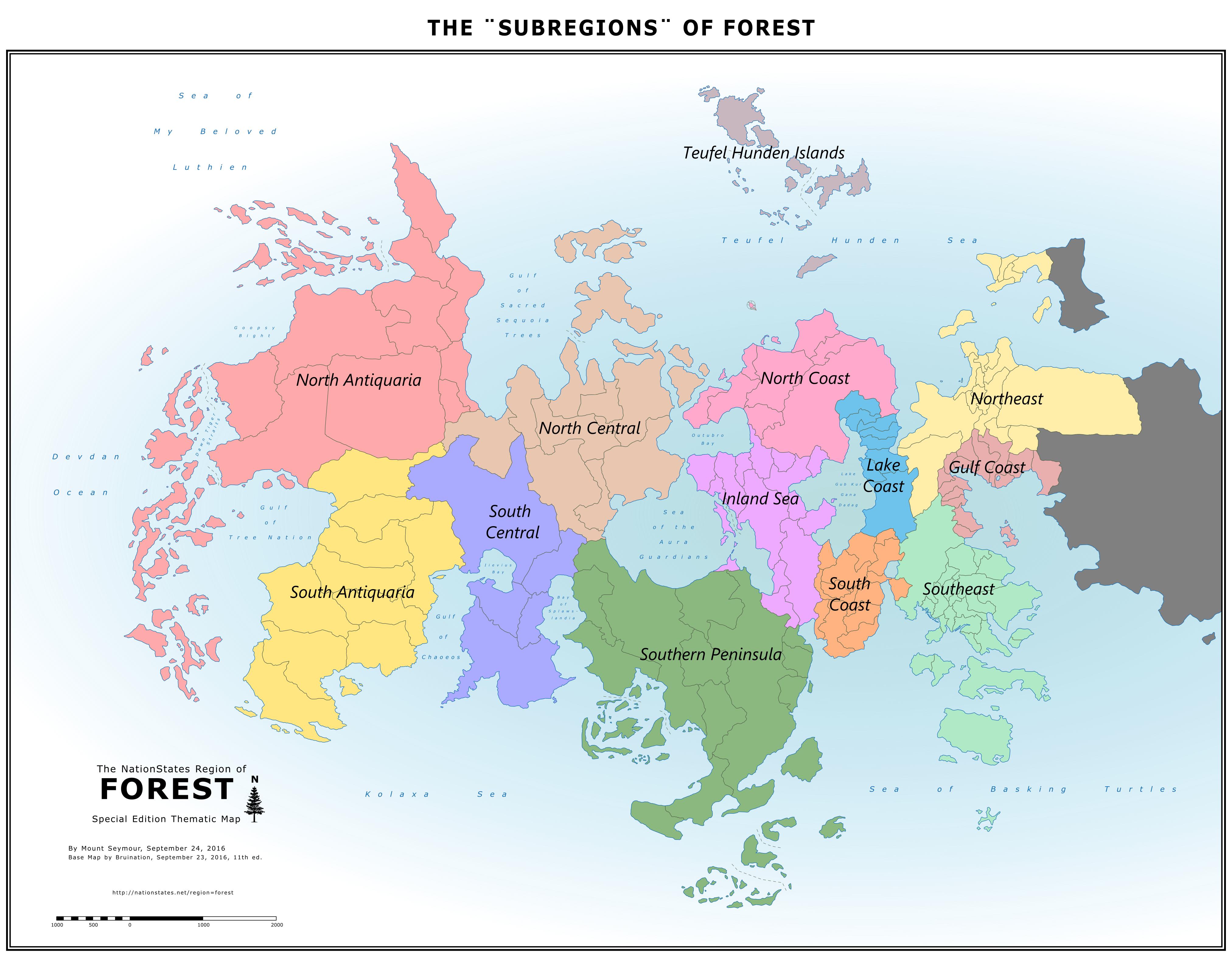
The "Subregions" of Forest |
The Greenest Nations in Forest By Mount Seymour |

How to Get on the Map
Please read this entire section before asking questions about the map.
If you don't find answers to your questions here, please telegram the cartographer, Bruination, instead of asking on the regional message board (RMB).
Every nation that moves to Forest has the opportunity to be automatically added to the map. Asking to be put on the map is not the way to get on it. The map eligibility criteria is designed to reward and encourage active participation and longevity with inclusion on the map, meaning nations that move to the region and remain inactive are unlikely to be included.
Map Eligibility
After joining Forest and remaining in the region for 30 consecutive days, a nation will be evaluated for map eligibility based on the following:
At the time of evaluation, the nation must have signed in within the last 15 days AND meet one or more of the following criteria:
1) It is a WA member and has endorsed the regional delegate; OR
2) It has contributed to discussions* on the regional message board (RMB) in the last 30 days; OR
3) It has registered for the  off-site forum and has posted at least once in the last 30 days; OR
4) It has at least 1 billion citizens and has addressed at least 12 issues in the last 6 days.
* This is the most subjective of the criteria. Generally it means RMB posts with content and value. One good post may have enough, whereas a dozen posts of little substance may not. Spam is highly discouraged.
Once a nation is determined to be eligible, it will be marked for inclusion in the next map update, which may occur some weeks later. (Map update frequency currently ranges from about 4 to 8 weeks.)
During the wait to be included on the map, take some time to read Forest's newspaper, the Forest News Leaf, or even write an article! Contact Forest's publicist, Frieden-und Freudenland, for more details.
Second & Third Chances
A nation will immediately be given a second 30-day waiting period, followed by a second evaluation, IF:
1) It fails to meet any of the above criteria at the time of its first evaluation; OR
2) It departs or ceases to exist (CTEs) for any amount of time during its first 30-day waiting period and then returns.
A nation will immediately be given a third 30-day waiting period, followed by a third and final evaluation, IF:
1) It reaches 1 billion citizens after it failed its second chance; OR
2) It requests a third chance (but not a fourth) by sending a convincing telegram to the cartographer.
If a nation fails its third and final evaluation or departs or CTEs during its third waiting period, it forfeits its opportunity to get on the map.
Removal from the Map
Once a nation is already on the map, future changes to the above criteria will not affect it. A nation will usually only be removed from the map for one or more of the following reasons:
1) It ceases-to-exist (CTEs) and does not return within 60 days; OR
2) It departs Forest for another region and does not return within 10 days; OR
3) It requests removal.
A nation that has been removed from the map for CTEing or departing is treated as a new arrival if it returns to Forest, with a new set of three chances to become eligible again. However, at the cartographer's discretion, a nation that has been added and removed repeatedly may run out of chances to be re-added again in the future.
How the Map Works
In order to leave much up to the imagination, there is no reference to an exact scale or latitude. The scale in the bottom left corner does not specify a unit of length and is purely decorative. The position of an equator and/or polar circle(s) can be imagined anywhere on the map or not at all. An individual nation can be considered large or small; hot, cold, humid, arid, or highly varied. Features such as mountains, rivers, small lakes, cities, and transportation networks are also left absent for this same purpose.
As a Timeline

As a Measure of Population
* Land Area units: Since the image is drawn as a vector graphic (SVG), these numbers don't represent a specific unit until the image is given a fixed scale, i.e. converted to a raster graphic (PNG). At the scale at which the map is currently uploaded, 1 unit equals 49 square pixels.
What Can Be Requested
Size and longitude are determined by the above described functions of the map and cannot usually be requested. The only requests for size that may be granted are for a nation to be represented smaller than it otherwise would be. However, there are still a number of other things a resident can request for their nation: relative latitude (northsouth position), general shape, whether it's landlocked or coastal. Examples of specific features that can be requested include a bay, peninsula, cape, isthmus, lake shore, island(s), etc. All ideas about a nation's context and shape and any existing maps of a nation are welcome to be shared with the cartographer, Bruination, to guide him in shaping it. In the absence of any specific requests, the position and shape of a nation will be up to the cartographer's discretion.
Archive of Past Maps
Bruination Series(2015Present)
164 Nations |
Added (14): Bad hair day zombies, Mesa Golden, Isbjorn Maerenne Bava Paerani, Tremessim, Zwangzug, The Half Moon Mountains, Perdox Nia, Draught, Ruinenlust, Mimisbrunnr, Terumbrae, Distant Winds, Ursus Arctos, Atlxianu Expanded (17): Navell, Communal Ecotopia, Bearadise, Asghef, La Rana Toro, The Mockingbird, Sethian, Aifur, Dogon, Baiana, Alpine Republics, Us harpies, Treepublic, Forceana, Unhuman Reserves, Venca, Night Vale Landia Removed (12): Romanax, Mastralos, Galapagos Preservation, DarkLife, Murmuria, Rakuencia, Udippia Other: Some nations that have ceased-to-exist (CTEd) have now been memorialized as Regional Preserves as an alternative to returning them to the sea. | |
157 Nations |
Added (18): Composted Orange Peels, John Senat, MariannaLand, Eryndlynd, Tomathinia, Caelestra, Plantaelia, Unhuman Reserves, Tsuga Canadensis, Venca, Night Vale Landia, Montmorencia, Turtlesturtlesturtles, Naasseners, Pacaraima, Paxadentia, Belgianadia, Yuumura Kirika Expanded (23): Idryll, Errinundera, Dogon, Baiana, Zephyr Grove, Frieden-und Freudenland, Prettycity, Doxovia, Flooby Nooby, Lebowskiberg, Woodland Partisans, Khromanapolis, Okefenokee Swamp, The kingdom of Jewelland, Bruination, Beauty of Nature, The Haunted Woods, Dazed Butterflies, Elfendel, Murflonia, Daior, Discordiae, Crasterram Removed (12): Eco2k, Aiadis, Socialist Bohemoravia, Sungreen, Huakahako, Avaridor, Eco darwinists, Guman, Skogens vrede, Port Peyton, Gansolandia, Beaverriver | |
151 Nations |
Added (17): Awazi, Beauty of Nature, Romanax, New Lvsitania, Nimros, Doxovia, Us harpies, Treepublic, Prettycity, The Hippy Union, Calenmor, Forceana, Crasterram, Khromanapolis, Body and Soul, Discordiae, Galapagos Preservation Expanded (18): Walquiria, Icalli, Yeland, DarkLife, Tremarctos, Yern, Nation of Eurasia, Mastralos, Leafapolis, Maple Hollow, Sethian, Aifur, The Vegan Commune, The Socialist Pure Land, Oecos, Mount Seymour, European Social Republic, Reconquered Spain Removed (5): Special Circumstances, The Hill, Diplocaulus, Altruismia, Kung Fu Penguin | |
139 Nations |
Added (9): Chan Island, Special Circumstances, Alpine Republics, Murmuria, Woodland Partisans, Zephyr Grove, Flooby Nooby, Okefenokee Swamp, Lebowskiberg Expanded (7): La Rana Toro, Memeplex, Mag Meall, Democratic Republic of Europa, Morgrim, Tribe Ravenclaw, Earth Worshippers Removed (2): Nordanland, Laelendell | |
132 Nations |
Added (20): Yeland, Mastralos, Idryll, DarkLife, Sethian, Gansolandia, The Haunted Woods, Illiniana, Yoshi, Byzonaea, Aifur, Port Peyton, Mount Seymour, Oecos, Beaverriver, Aengloland, Dogon, Shilmesta, Baiana, Brellach Expanded (15): The Mirshism Cult, Bearadise, Caracasus, The Vegan Commune, The Socialist Pure Land, Guman, European Social Republic, Reconquered Spain, Topaia, Ventus Aeternam, Stereotypia, Ulfstead, Bemberna, Chula, Latusgardd Removed (12): Oberonn, Metroqolia, Catalasa, Vivatrex, Sinaasappelsap, The Elba, Bearsendland, Anarchist Resistance, Regional Cartographer Office, Hollietopia, The Brink of Extinction, Eastcorner Other: Conoistre & Yern relocated to islands; Corrected spelling of Ventus Aeternam. | |
124 Nations |
Added (14): La Rana Toro, Huakahako, Elfendel, The Mockingbird, Basella, Aiadis, New Internationalists, Sungreen, The Socialist Pure Land, European Social Republic, Reconquered Spain, Nation of Eurasia, Leafapolis, Walquiria Expanded (12): Shalotte, Sam I am, Yern, Taco Respublic, Eco2k, Maple Hollow, Tremarctos, Wise Witches, CoolDayna, Asghef, Araneidae, Ashrah Removed (14): Republic of blaine, The Ash Tree, Wolvenia, The Ecological Right, Psychedelic zebras, Malzur, The laid back hippies, Iliocostallis, Msitu Kongwe, Zephyr Grove, Splawslandia, Faunastia, Blue DG, Peameal Other: More bodies of water named after prominent former members: Bay of Splawslandia, Teufel Hunden Sea, Sea of Basking Turtles, & Lake Gub Kur Gana Dadag. | |
124 Nations |
Added (4): My Comfortable Bed, Daior, The Hill, Icalli Expanded (12): New Chechovenia, Ironic Remarks, Bruination, Eco darwinists, Froenburg, Dazed Butterflies, Kegars, Hollietopia, Altruismia, Rakuencia, Mag Meall, Democratic Republic of Europa Removed (5): Great Lakes Metropoleis, Goopsy, Hyastick, Lexbourg, Aurum Mundum Other: Gulf of Dawn Tiger changed to Dawn Tiger Straits and several more bodies of water named after prominent former members: Gulf of Tree Nation, Goopsy Bight, Gulf of Chaoeos, Iievius Bay, Gulf of Sacred Sequoia Trees, Outubro Bay, & Sea of the Aura Guardians. | |
125 Nations |
Added (15): Yern, Rakuencia, Eco2k, Great Lakes Metropoleis, Avaridor, Maple Hollow, Bearsendland, Laelendell, Tremarctos, Mag Meall, Land o Birds, Democratic Republic of Europa, Guman, The Vegan Commune, Sam I am Expanded (9): Socialist Bohemoravia, Free Bears in the Wood, Nordanland, Topaia, Frieden-und Freudenland, Ventus Aeternam, Catalasa, Stereotypia, Ulfstead Removed (5): Eco-terrorists, Mars Base One, Centaurs, Janlandia, Redwood Wood Wood Other: Several other nations changed shape as their neighbors disappeared or expanded. | |
115 Nations |
Added (8): Agadin, Island Number Nine, Oberonn, Altruismia, Iliocostallis, Anarchist Resistance, Skogens vrede, Msitu Kongwe Expanded (14): The night garden, Zephyr Grove, Ransium, Kawastyselir, Autonomousness, Belinos, Blue DG, Wise Witches, Regional Cartographer Office, Asghef, Family Bear, Siberian Taiga, GRO-Environment, Bearadise Removed (7): Wayonn, The Apes, Venhova, Spectre land, Caloviso, Aokigahara Forest, Forest Swamp Other: Map expanded eastward. Aurum Mundum repositioned after typo led to initial placement too far east. | |
114 Nations |
Added (12): Morgrim, Wolvenia, Regional Cartographer Office, The Brink of Extinction, Malzur, Asghef, Catalasa, Stereotypia, Kung Fu Penguin, Ulfstead, The Ecological Right, Socialist Bohemoravia Expanded (0): none Removed (1): The Yogic Nation of Muchkarmanow Other: Southeast coast reshaped | |
103 Nations |
This was the first in the series, so everything was new. | |
|
|
|
Santa Joanna Series(20122014)
|
April 30, 2012 |
April 19, 2012 |
April 5, 2012 |
March 11, 2012 |
February 7, 2012 The Oldest Map of Forest |
Thematic Maps:
|
Commemorative 100 Nation Map, March 31, 2013 Credit: Ransium |
Forest from the Air (3D Map), March 4, 2013 Credit: Hesperika |
Choropleth: Eco-Friendliness, August 24, 2012 Credit: Naturesocialistic Aryaland |
Since I prefer not to link directly to a map image with no context, we now have the pinned dispatch and the small WFE link going to the same place. I'm not sure whether to reduce the two links to just one, or which to narrow it down to, so for now I've kept both. Perhaps that's okay for the added visibility?
Shalotte, Archenomia, Peppsiland, Gro-environment, and 5 othersGil zardon, Frieden-und Freudenland, Dazed butterflies, Ventus aeternam, and Canaltia
Hey, we have the world's smallest timber woodchipping industry - yet again!
I wish we could get badges for this.
Shalotte and Canaltia
We get trees and air for it!
Plus, if we are ever a featured region again the WFE is what they show, so mentioning the map is useful.
Shalotte, Frieden-und Freudenland, Bruination, and Canaltia
Good point.
By the way, how do they select the featured region? Are there certain criteria or is it just random?
As far as I'm aware it just needs to be a region that isn't password protected. After that it's just random.

Hi all, still on holiday, but in a hostel w/ wifi and on my phone. I haven't read CE's constitution so I can't comment on it. I think forest is essentially a constitutional monarchy w/ a strong prime minister role similar to the UK. I want the constitution to cover positions powers, elections, embassies, etc. Can cover in more detail when I get back or should have draft by end of December latest...
Shalotte, Frieden-und Freudenland, and Canaltia
It's actually snowed on me on the keepler trek, so I'm not sure I've learned anything...
Frieden-und Freudenland, Bearadise, and Canaltia
«12. . .212213214215216217218. . .2,6482,649»
Advertisement


