


«12. . .2,0822,0832,0842,0852,0862,0872,088. . .2,6472,648»

I accidentally suppressed a post on mobile but immediately unsuppressed it. Just letting everyone know for transparency.
Einswenn, Atsvea, Ruinenlust, Lord Dominator, and 5 othersUan aa Boa, Terrabod, Middle Barael, Nation of ecologists, and Garbelia

That's often my strategy as well, but I decided to make this one deliberately a bit more of a challenge :-D
In this case, despite the level of detail, one entire statement is false. I am not a mountaineer, and have no love of hiking whatsoever - I've never climbed on any of the seven summits, much less summited one! I have taken those master classes though, and have indeed held one of those coins (along with a heck of a lot of other extreme rarities!).
Mount Seymour, Atsvea, Ruinenlust, Lord Dominator, and 5 othersSimbolon, Middle Barael, Nation of ecologists, Garbelia, and The most serene republicans

Interestingly to the topic at hand, for the brief period that I was involved with the map (the VERY early stages of the current one irc) I had wanted to, and suggested doing, an in depth survey of RP geography, weather, and biomes before determining nation placement in order to ensure that the locations of the various nations and, thus, the makeup of the "world" of Forest actually made sense. In the end though, I didn't have the RW time and we all wanted to get something put out for everyone to enjoy sooner rather than later, so it ended up not happening.
Verdant Haven, Mount Seymour, Atsvea, Ruinenlust, and 5 othersLord Dominator, Terrabod, Middle Barael, Nation of ecologists, and Garbelia
Just a question, do we have a designated map maker right now? I know  Middle Barael is the lore minister, however im not sure if they work on the map or not.
Atsvea, Lord Dominator, Terrabod, Middle Barael, and 2 othersGarbelia, and The most serene republicans

See the bottom of this post by Chan explaining our current situation.
Einswenn, Calenmor, Mount Seymour, Atsvea, and 6 othersRuinenlust, Lord Dominator, Middle Barael, Nation of ecologists, Garbelia, and The most serene republicans
ah, I see. Thanks!
Update on the GII: I haven't really found the time to make it, but hopefully on the weekend I can start with at least getting environmentalism done.
Atsvea, Ruinenlust, Lord Dominator, Terrabod, and 3 othersMiddle Barael, Garbelia, and The most serene republicans
To be fair, because map positions, nation shapes, etc were already determined for many of us long before the current reskin and expansion of the map was created (it came over from Areulder's work previously - see below), it probably would have caused problems to try moving nations around! You likely avoided some frustration by not doing so.
Honestly, I just completely ignore the climate map, since that was invented long after the rest and paid no regard to the work already done by a number of nations. It's neat to have, for sure, but is irrelevant to my lore. Errinundera was a temperate rainforest, for example, but the climate map turned the center of it into a desert! Verdant Haven is a Mediterranean Climate nation, largely of the Warm-Summer variety (though Cold-Summer up in the mountains), with areas of Oceanic Climate on the east coast, and its location in the earlier map was partly chosen due to that fact.
Here's the old map:

Can I get onto the map?
Forest's map operated on an opt in basis. Any nation wishing to join the regional map must have a regional Influence rating of 30 SPDR or higher. You can check your regional influence here. Influence is a measure of a combination of World Assembly endorsements and length of time spent in a region. Nations below 30 SPDR must wait until they reach that level before applying.
How big can I be?
You may not request an area for your nation larger than approximately 500 by 500 pixels (a 500×500 box is located on the bottom right of the map for reference) on the full uploaded map scale unless you have 100 SPDR or over. If you surpass 100 SPDR and would like to request a larger size, please telegram the cartographers with your new request.
What Else Can Be Requested
You may request a specific size for your nation so long as it is below the requirements listed above. You may request a specific location, access to a river, water, landlocked status, etc. so long as it is within reason. If you would like your nation in a specific location on the map, please check on the biome map[pending] to make sure that its climate matches that area appropriately.
The cartographers reserve the right to refuse to add or to edit any nation or feature on the regional map.
The Form
Please use this form to send your application to the head cartographer Areulder.
Nation name:
Capital city:
Climate/biome:
Location if you have a preference:
Significant geographical features (mountains, rivers, etc. and where they are located):
Any maps of your nation you wish to share with the cartographers:
Any other information or requests:
Calenmor, Atsvea, Ruinenlust, Lord Dominator, and 5 othersUan aa Boa, Middle Barael, Nation of ecologists, Garbelia, and The most serene republicans
The climate map is interesting though because its meant to be realistic.
Einswenn, Atsvea, Ruinenlust, Lord Dominator, and 5 othersUan aa Boa, Middle Barael, Nation of ecologists, Garbelia, and The most serene republicans
Agreed, it is interesting! It's a fascinating exercise in applying certain Earth concepts to a hypothetical world. I admire the effort it took to make. "Interesting" is where it ends for me though, because that realism only applies if you have a certain set of assumptions, which aren't necessarily shared by those who were already on the map when those assumptions got applied. The idea that the climate classifications share similar associations with latitude as they do on Earth is an external assumption, and things like the movement direction of winds (and the implied rotational direction of the planet) aren't implicitly "true" - they had to be declared. The size of the planet, based on the distance between latitude lines, also appears assumed to be Earth-like. Even accepting all of those things and saying "fine, it's Earth" the question of which hemisphere Forest is in, and where those latitude lines are placed, were later applications after many nations were on the map.
Basically, it had to make a bunch of assumptions, and then applied those assumption to a world that had already seen extensive world-building. As we are not an RP region, and enforce no particular compliance on our citizens, the climate map remains to me an interesting-but-unusable exercise. It shows me what the climate zones might be, if Forest (and as a result, Verdant Haven) were in some other place, on some other planet, in some other hemisphere or latitude than where it "is" for my purposes.
Calenmor, Atsvea, Ruinenlust, Lord Dominator, and 3 othersMiddle Barael, Nation of ecologists, and The most serene republicans

Meant to be. I looked over and tweaked the climate maps for Octopus Islands before they were published, but the difficulty is not really knowing the elevation scheme of the land. So areas that may have been wet turned dry, or the opposite. Ideally, one would have the elevation map, and then you'd go from there. Imagine, for instance, if the western states in the US were flat, and if there were huge mountains across the Southeastern US from west to east. Or if the Alps didn't exist. Mountain ranges are much of the story with precipitation patterns.
But I tried to make things realistic-ish.
Verdant Haven, Calenmor, Mount Seymour, Atsvea, and 7 othersLord Dominator, Uan aa Boa, Terrabod, Middle Barael, Nation of ecologists, Garbelia, and The most serene republicans

And then there's the really old map, which I still remember fondly:
NOTE: Before asking questions about the map, please read the entire section below titled How to Get on the Map. If you don't find answers to your questions here, please telegram the cartographer, Bruination, instead of asking on the regional message board (RMB).
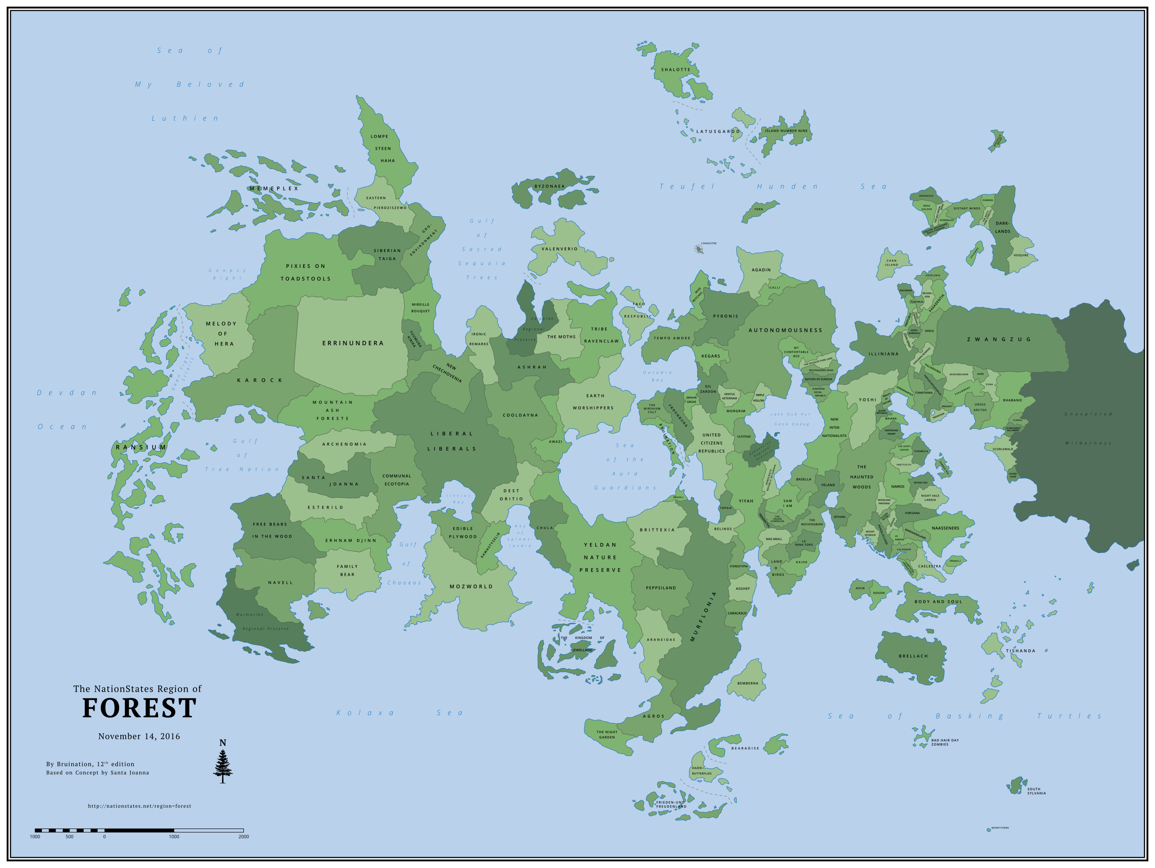
Introduction Forest's regional map is one of the largest on NationStates and differs from most in a few key ways. It is not an opt-in map on which nations must request inclusion. Nations are automatically added as long as they meet certain criteria based on the nation's participation in the region. Forest's map has two main functions: Firstly, it uniquely serves as a timeline of when each nation first arrived in Forest, with the earliest arrivals positioned to the west and the latest to the east. Secondly, it illustrates every nation's relative population, with more populous nations occupying more land area. The land and coastline evolve with each new update, as nations arrive, grow, or depart. The map is not primarily a role-play tool, although it can be used as one.
The original map series of Forest was begun by Santa Joanna in February 2012 and continued until September 2014. After a year with no further updates, Bruination began work on reviving the regional map with a new layout and style, while honoring the traditions set by Santa Joanna of using the map as both a timeline and a representation of population size. The first edition of Bruination's series was released in November 2015. By June 2016, the map had grown to depict 151 nations, the highest number on any known regional map on NationStates at the time. |
Contents |
Changes in This Edition:
Added (18)
Arbb, The misty pine forests, Euna, Purabella, Tishanda, Rhabano, Eumangi, Scorlewald, Monpiterre, Nouvelle bouef, Darklands, Le parlement des arbres, Vesquire, South sylvania, Bondaisia, Hazelonia, Cosireshire, IcareaExpanded (21)
Mount Seymour, Prettycity, Woodland partisans, Wise Witches, Nimros, Mireille bouquet, Stereotypia, Okefenokee swamp, Peppsiland, Ulfstead, Belgianadia, Eryndlynd, Gil zardon, Mag meall, Terumbrae, Agadin, Democratic republic of europa, Tempo amore, Aengloland, Chan island, The MothsRemoved (11)
Delionera, Oecos, Shilmesta, New Lvsitania, Idryll, Lebowskiberg, Walquiria, Leafapolis, Nonus The Hobo, Crasterram, ElfendelTotal Nations: 171
Previous Edition: 164
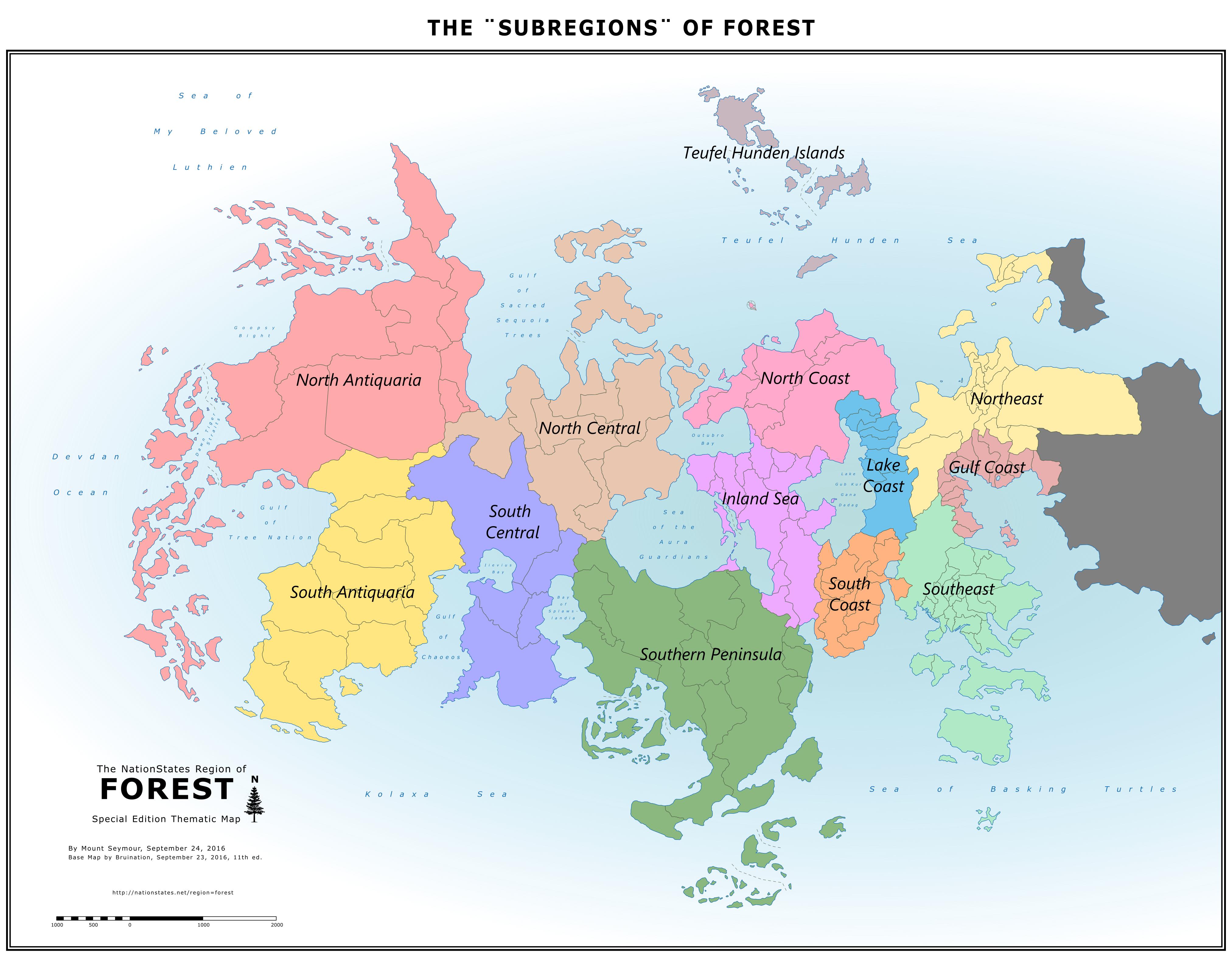
The "Subregions" of Forest |
The Greenest Nations in Forest By Mount Seymour |

How to Get on the Map
Please read this entire section before asking questions about the map.
If you don't find answers to your questions here, please telegram the cartographer, Bruination, instead of asking on the regional message board (RMB).
Every nation that moves to Forest has the opportunity to be automatically added to the map. Asking to be put on the map is not the way to get on it. The map eligibility criteria is designed to reward and encourage active participation and longevity with inclusion on the map, meaning nations that move to the region and remain inactive are unlikely to be included.
Map Eligibility
After joining Forest and remaining in the region for 30 consecutive days, a nation will be evaluated for map eligibility based on the following:
At the time of evaluation, the nation must have signed in within the last 15 days AND meet one or more of the following criteria:
1) It is a WA member and has endorsed the regional delegate; OR
2) It has contributed to discussions* on the regional message board (RMB) in the last 30 days; OR
3) It has registered for the  off-site forum and has posted at least once in the last 30 days; OR
4) It has at least 1 billion citizens and has addressed at least 12 issues in the last 6 days.
* This is the most subjective of the criteria. Generally it means RMB posts with content and value. One good post may have enough, whereas a dozen posts of little substance may not. Spam is highly discouraged.
Once a nation is determined to be eligible, it will be marked for inclusion in the next map update, which may occur some weeks later. (Map update frequency currently ranges from about 4 to 8 weeks.)
During the wait to be included on the map, take some time to read Forest's newspaper, the Forest News Leaf, or even write an article! Contact Forest's publicist, Frieden-und Freudenland, for more details.
Second & Third Chances
A nation will immediately be given a second 30-day waiting period, followed by a second evaluation, IF:
1) It fails to meet any of the above criteria at the time of its first evaluation; OR
2) It departs or ceases to exist (CTEs) for any amount of time during its first 30-day waiting period and then returns.
A nation will immediately be given a third 30-day waiting period, followed by a third and final evaluation, IF:
1) It reaches 1 billion citizens after it failed its second chance; OR
2) It requests a third chance (but not a fourth) by sending a convincing telegram to the cartographer.
If a nation fails its third and final evaluation or departs or CTEs during its third waiting period, it forfeits its opportunity to get on the map.
Removal from the Map
Once a nation is already on the map, future changes to the above criteria will not affect it. A nation will usually only be removed from the map for one or more of the following reasons:
1) It ceases-to-exist (CTEs) and does not return within 60 days; OR
2) It departs Forest for another region and does not return within 10 days; OR
3) It requests removal.
A nation that has been removed from the map for CTEing or departing is treated as a new arrival if it returns to Forest, with a new set of three chances to become eligible again. However, at the cartographer's discretion, a nation that has been added and removed repeatedly may run out of chances to be re-added again in the future.
How the Map Works
In order to leave much up to the imagination, there is no reference to an exact scale or latitude. The scale in the bottom left corner does not specify a unit of length and is purely decorative. The position of an equator and/or polar circle(s) can be imagined anywhere on the map or not at all. An individual nation can be considered large or small; hot, cold, humid, arid, or highly varied. Features such as mountains, rivers, small lakes, cities, and transportation networks are also left absent for this same purpose.
As a Timeline
As a Measure of Population
* Land Area units: Since the image is drawn as a vector graphic (SVG), these numbers don't represent a specific unit until the image is given a fixed scale, i.e. converted to a raster graphic (PNG). At the scale at which the map is currently uploaded, 1 unit equals 49 square pixels.
What Can Be Requested
Size and longitude are determined by the above described functions of the map and cannot usually be requested. The only requests for size that may be granted are for a nation to be represented smaller than it otherwise would be. However, there are still a number of other things a resident can request for their nation: relative latitude (northsouth position), general shape, whether it's landlocked or coastal. Examples of specific features that can be requested include a bay, peninsula, cape, isthmus, lake shore, island(s), etc. All ideas about a nation's context and shape and any existing maps of a nation are welcome to be shared with the cartographer, Bruination, to guide him in shaping it. In the absence of any specific requests, the position and shape of a nation will be up to the cartographer's discretion.
Archive of Past Maps
Bruination Series(2015Present)
164 Nations |
Added (14): Bad hair day zombies, Mesa Golden, Isbjorn Maerenne Bava Paerani, Tremessim, Zwangzug, The Half Moon Mountains, Perdox Nia, Draught, Ruinenlust, Mimisbrunnr, Terumbrae, Distant Winds, Ursus Arctos, Atlxianu Expanded (17): Navell, Communal Ecotopia, Bearadise, Asghef, La Rana Toro, The Mockingbird, Sethian, Aifur, Dogon, Baiana, Alpine Republics, Us harpies, Treepublic, Forceana, Unhuman Reserves, Venca, Night Vale Landia Removed (12): Romanax, Mastralos, Galapagos Preservation, DarkLife, Murmuria, Rakuencia, Udippia Other: Some nations that have ceased-to-exist (CTEd) have now been memorialized as Regional Preserves as an alternative to returning them to the sea. | |
157 Nations |
Added (18): Composted Orange Peels, John Senat, MariannaLand, Eryndlynd, Tomathinia, Caelestra, Plantaelia, Unhuman Reserves, Tsuga Canadensis, Venca, Night Vale Landia, Montmorencia, Turtlesturtlesturtles, Naasseners, Pacaraima, Paxadentia, Belgianadia, Yuumura Kirika Expanded (23): Idryll, Errinundera, Dogon, Baiana, Zephyr Grove, Frieden-und Freudenland, Prettycity, Doxovia, Flooby Nooby, Lebowskiberg, Woodland Partisans, Khromanapolis, Okefenokee Swamp, The kingdom of Jewelland, Bruination, Beauty of Nature, The Haunted Woods, Dazed Butterflies, Elfendel, Murflonia, Daior, Discordiae, Crasterram Removed (12): Eco2k, Aiadis, Socialist Bohemoravia, Sungreen, Huakahako, Avaridor, Eco darwinists, Guman, Skogens vrede, Port Peyton, Gansolandia, Beaverriver | |
151 Nations |
Added (17): Awazi, Beauty of Nature, Romanax, New Lvsitania, Nimros, Doxovia, Us harpies, Treepublic, Prettycity, The Hippy Union, Calenmor, Forceana, Crasterram, Khromanapolis, Body and Soul, Discordiae, Galapagos Preservation Expanded (18): Walquiria, Icalli, Yeland, DarkLife, Tremarctos, Yern, Nation of Eurasia, Mastralos, Leafapolis, Maple Hollow, Sethian, Aifur, The Vegan Commune, The Socialist Pure Land, Oecos, Mount Seymour, European Social Republic, Reconquered Spain Removed (5): Special Circumstances, The Hill, Diplocaulus, Altruismia, Kung Fu Penguin | |
139 Nations |
Added (9): Chan Island, Special Circumstances, Alpine Republics, Murmuria, Woodland Partisans, Zephyr Grove, Flooby Nooby, Okefenokee Swamp, Lebowskiberg Expanded (7): La Rana Toro, Memeplex, Mag Meall, Democratic Republic of Europa, Morgrim, Tribe Ravenclaw, Earth Worshippers Removed (2): Nordanland, Laelendell | |
132 Nations |
Added (20): Yeland, Mastralos, Idryll, DarkLife, Sethian, Gansolandia, The Haunted Woods, Illiniana, Yoshi, Byzonaea, Aifur, Port Peyton, Mount Seymour, Oecos, Beaverriver, Aengloland, Dogon, Shilmesta, Baiana, Brellach Expanded (15): The Mirshism Cult, Bearadise, Caracasus, The Vegan Commune, The Socialist Pure Land, Guman, European Social Republic, Reconquered Spain, Topaia, Ventus Aeternam, Stereotypia, Ulfstead, Bemberna, Chula, Latusgardd Removed (12): Oberonn, Metroqolia, Catalasa, Vivatrex, Sinaasappelsap, The Elba, Bearsendland, Anarchist Resistance, Regional Cartographer Office, Hollietopia, The Brink of Extinction, Eastcorner Other: Conoistre & Yern relocated to islands; Corrected spelling of Ventus Aeternam. | |
124 Nations |
Added (14): La Rana Toro, Huakahako, Elfendel, The Mockingbird, Basella, Aiadis, New Internationalists, Sungreen, The Socialist Pure Land, European Social Republic, Reconquered Spain, Nation of Eurasia, Leafapolis, Walquiria Expanded (12): Shalotte, Sam I am, Yern, Taco Respublic, Eco2k, Maple Hollow, Tremarctos, Wise Witches, CoolDayna, Asghef, Araneidae, Ashrah Removed (14): Republic of blaine, The Ash Tree, Wolvenia, The Ecological Right, Psychedelic zebras, Malzur, The laid back hippies, Iliocostallis, Msitu Kongwe, Zephyr Grove, Splawslandia, Faunastia, Blue DG, Peameal Other: More bodies of water named after prominent former members: Bay of Splawslandia, Teufel Hunden Sea, Sea of Basking Turtles, & Lake Gub Kur Gana Dadag. | |
124 Nations |
Added (4): My Comfortable Bed, Daior, The Hill, Icalli Expanded (12): New Chechovenia, Ironic Remarks, Bruination, Eco darwinists, Froenburg, Dazed Butterflies, Kegars, Hollietopia, Altruismia, Rakuencia, Mag Meall, Democratic Republic of Europa Removed (5): Great Lakes Metropoleis, Goopsy, Hyastick, Lexbourg, Aurum Mundum Other: Gulf of Dawn Tiger changed to Dawn Tiger Straits and several more bodies of water named after prominent former members: Gulf of Tree Nation, Goopsy Bight, Gulf of Chaoeos, Iievius Bay, Gulf of Sacred Sequoia Trees, Outubro Bay, & Sea of the Aura Guardians. | |
125 Nations |
Added (15): Yern, Rakuencia, Eco2k, Great Lakes Metropoleis, Avaridor, Maple Hollow, Bearsendland, Laelendell, Tremarctos, Mag Meall, Land o Birds, Democratic Republic of Europa, Guman, The Vegan Commune, Sam I am Expanded (9): Socialist Bohemoravia, Free Bears in the Wood, Nordanland, Topaia, Frieden-und Freudenland, Ventus Aeternam, Catalasa, Stereotypia, Ulfstead Removed (5): Eco-terrorists, Mars Base One, Centaurs, Janlandia, Redwood Wood Wood Other: Several other nations changed shape as their neighbors disappeared or expanded. | |
115 Nations |
Added (8): Agadin, Island Number Nine, Oberonn, Altruismia, Iliocostallis, Anarchist Resistance, Skogens vrede, Msitu Kongwe Expanded (14): The night garden, Zephyr Grove, Ransium, Kawastyselir, Autonomousness, Belinos, Blue DG, Wise Witches, Regional Cartographer Office, Asghef, Family Bear, Siberian Taiga, GRO-Environment, Bearadise Removed (7): Wayonn, The Apes, Venhova, Spectre land, Caloviso, Aokigahara Forest, Forest Swamp Other: Map expanded eastward. Aurum Mundum repositioned after typo led to initial placement too far east. | |
114 Nations |
Added (12): Morgrim, Wolvenia, Regional Cartographer Office, The Brink of Extinction, Malzur, Asghef, Catalasa, Stereotypia, Kung Fu Penguin, Ulfstead, The Ecological Right, Socialist Bohemoravia Expanded (0): none Removed (1): The Yogic Nation of Muchkarmanow Other: Southeast coast reshaped | |
103 Nations |
This was the first in the series, so everything was new. | |
|
|
|
Santa Joanna Series(20122014)
|
April 30, 2012 |
April 19, 2012 |
April 5, 2012 |
March 11, 2012 |
February 7, 2012 The Oldest Map of Forest |
Thematic Maps:
|
Commemorative 100 Nation Map, March 31, 2013 Credit: Ransium |
Forest from the Air (3D Map), March 4, 2013 Credit: Hesperika |
Choropleth: Eco-Friendliness, August 24, 2012 Credit: Naturesocialistic Aryaland |
An absolutely unbelievable amount of work went into that one. It was almost less a geographical map and more a data visualization of national and regional history.
Verdant Haven, Einswenn, Alcantaria, Calenmor, and 9 othersAtsvea, Ruinenlust, Lord Dominator, Uan aa Boa, Terrabod, Middle Barael, Nation of ecologists, Garbelia, and The most serene republicans
Glorious! Well done infographics and DVs are fantastic!
Calenmor, Mount Seymour, Atsvea, Ruinenlust, and 5 othersLord Dominator, Middle Barael, Nation of ecologists, Garbelia, and The most serene republicans
Hi, I want to interrupt whatever anyone's doing right now to inform that ten days ago, in the lovely concrete jungle that is São Paulo - SP, Brazil, A local druglord and several members of his gang (a local chapter of a large Mafia, the PCC) shot the air with a rifle several times to scare off and stop a funk ball from happening. The funk ball constituted a huge crowd, which goes again the gang's policy, which intends to stop the spread of COVID-91 in São Paulo.
In short: In Brazil, druglords are better at stopping Covid than the government.
Einswenn, Alcantaria, Calenmor, Chan island, and 12 othersMount Seymour, Atsvea, Ruinenlust, Lord Dominator, Uan aa Boa, Hoochlandia, Terrabod, Simbolon, Middle Barael, Nation of ecologists, Garbelia, and Difinbelk
Nice, so yeah, this fits.....
Uan aa boa is the motherland
Keplerians are a mixed culture of humans (Seetians) and alien furry-like people from Kaipar System(Filitans):
In 1350 BC. first humans arrive in Kepler, having a Finnic-like language and culture(Eesti+Suomi+Samo+Karjala mix).
In 114 BC Keplerians are colonized by a roman-like culture.
*Big improvements*
In cca 200 AC We get our independence and shattered into many city-states.
*Saaliq-Osomi wars(341-861 AC)*
*Time of peace*
In 947 AC We get united by Kepler Öromen into the land of Seeti.
*Several years of byzantine-like state*
In 1475 AC an ginormous asteroid quite softly hits the Vailar plain, creating Lake Üwano and the surrounding ones, out of the asteroid come the Filitians(Pirestoki people-birds= germanic-like culture, Aerit people- turtles= greek-like culture, Vainar people-Felines and Canines and Oilant people-Bears= Slavic-like culture)
*a minor war for land (1537-1575)*
1575 AC, peace deal between Bjär Kepler (Leader of Seeti) and Osoilin Ögwáii(Turtle leader of Filitians), cutting most ties with outer countries.
1641 AC Union of Kingdom of Seeti and Republic of Filiti, Starting of the Dual union of Kepler(Two leaders, a Seeti King(Inherited) and a Filitian Consul(elected)), re-linking ties to the outer world.
(MINOR ADDITION: the suffix -0085 is non-canon)
Calenmor, Atsvea, Ruinenlust, Lord Dominator, and 4 othersMiddle Barael, Nation of ecologists, Garbelia, and The most serene republicans
Covid-91? Damn, I must have missed some of its iterations...
For real though, the way that governments and some people approach the pandemic just infuriates me. I get that there are economic concerns, but come on, this is people's health we are talking about! How can the economy be more important than making sure that people stay safe and healthy? The coronavirus is not just a flu, it's a serious virus that ravages the human body. It leaves lasting complications like nerve damage, lung damage, heart damage, and yet people seem only be able to care about going to the pub again, going to festivals or vacationing. Like, has that really become the sole sense of life of some people?
I guess this may sound somewhat ranty, but as someone who went through a covid infection it really annoys me to see how people and governmenta behave irresponsibly. They want to loosen restrictions when infection rates are still high, and that's just insanity to me. When you jump out of a plane with a parachute, you don't cut the cords of that parachute when it has slowed down your descent a little bit. You keep the parachute on until you reach the ground.
Mount Seymour, Atsvea, Ruinenlust, Lord Dominator, and 5 othersUan aa Boa, Terrabod, Middle Barael, Nation of ecologists, and Garbelia

Well, thats more a Brazilian government problem more than a problem of government itself... any Brazilians here?
Mount Seymour, Ruinenlust, Lord Dominator, Middle Barael, and 2 othersNation of ecologists, and Garbelia

This is unbelievable :0 I feel a lot of shame for how my beloved Brazil is being laughed at around the world.
Well, I consider myself a false Brazilian since I've been studying Brazilian Portuguese for 5 years and have been in love with this country, its music and culture since.
I am well aware of the situation there thanks to some Brazilian friends, which does not prevent me from wanting to live there XD
Mount Seymour, Atsvea, Ruinenlust, Lord Dominator, and 3 othersMiddle Barael, Nation of ecologists, and Garbelia
How do you think we felt in the USA with the rotten pumpkin man-baby whom daddy never loved for the past half-decade?
At least I don't think people are laughing at Brazil, exactly. Bolsonaro is in fact a jackass, and has tens of thousands of excess death on his hands, but overall, I think there's more a sense of pity and sorrow for the people who are effectively held hostage by his rule by stupidity.
Whereas in the United States, until the pandemic at least, it was like Trump's mission was to try to look as dumb and inarticulate and immature as possible. And then of course Trump also now has the deaths of hundreds of thousands of excess COVID deaths on his hands, for his ability to only make things worse and to drive things in the ground. And then you have the spineless anti-party formerly known as the Republicans, who share in his guilt for having supported him and having voted for him.
I've never been so angry or so resolutely opposed to an entire political party as I am for the past few years. Trump made me into a lifelong DBD: Democrat By Default. And you'd think perhaps that after a few months of the antipresident being gone, things would cool down, but for me it's like a huge volcano that is just sleeping a bit more often. But the magma is right below the surface, waiting for the very primary election, midterm election, general election, etc. And although the near-constant schadenfreude of 2021 in the face of the Republicans' misfortune and Trump's demise is a sweet, cooling rain on a destroyed and twisted landscape, nevertheless the volcano lurks just beneath the surface, and the wounds will not heal for a long, long time. And for those who died, or for those who were lost to the propaganda of the right wing media and to Trump's incoherent, ecocentric ramblings, the damage is terminal, I'm afraid.
Then again, maybe it's more similar than I realize at first, the situation in the United States and Brazil.
So it goes, I guess, when idiot rulers destroy their countries and impoverish and harm their citizens.
Alcantaria, Mount Seymour, Atsvea, Lord Dominator, and 6 othersUan aa Boa, Terrabod, The Teeth, Middle Barael, Nation of ecologists, and Garbelia

I'm totally with you that a lot of governments have been prioritising the survival of big businesses over human health, but economics is also about individuals ability to buy food and pay rent.
Most countries don't have good enough social welfare to support people through quarantine, which is the fault of past government choices.
The issue is that we forgot that pandemics happen. We thought we were immune to everything now that we have antibiotics, when we're actually more vulnerable than ever due to a chronic health pandemic and climate change.
I bet people wouldn't have such trouble staying home if we had Universal basic income.
Also, I had covid so I know how serious it is, but loneliness also kills people. for some people going to the pub was their only human contact and the stress of loneliness is seriously undermining their health.
I see that some people can't understand how serious covid is because they can't see it. a lot of people aren't very imaginative so they need to see a dead body to know that people are dying.
It's frustrating but it's human nature so I keep trying to remind myself that there's no use getting cross about it.
Mount Seymour, Atsvea, Ruinenlust, Lord Dominator, and 7 othersUan aa Boa, Toasternation, Middle Barael, Nation of ecologists, Garbelia, Difinbelk, and The reman starcluster

A Canadian says America is like that neighbor who has had their car alarm running for the last five years
Imagine what it is like being stuck in the car
Einswenn, Alcantaria, Mount Seymour, Atsvea, and 7 othersRuinenlust, Lord Dominator, Uan aa Boa, Hoochlandia, The Teeth, Nation of ecologists, and Garbelia
Im not laughing at Brazil itself, it's a beautiful country that just unfortunately elected Bolsonaro as leader. I'm not even mad at the people who voted for him, as Brazil had been going through a difficult time recently and right-wing populism is a helluva drug (*ahem* US *ahem*), so I even understand why some may have voted for him. Obviously that was one of their biggest mistakes they've ever made now, but that wasn't extremely obvious in 2018. So I guess just tough it out until 2022, and get him the hell out.
Alcantaria, Mount Seymour, Atsvea, Ruinenlust, and 6 othersDemocratic Republic of Cacusia, Lord Dominator, The Teeth, Toasternation, Middle Barael, and Garbelia

If he decides to leave, this is bolsonaro, it wouldnt surprise me if he just claimed the election was corrupt and stayed.
Atsvea, Lord Dominator, Middle Barael, Nation of ecologists, and 1 otherGarbelia

My tastes probably aren't highbrow enough, but I'd say that Lukas Graham's 7 years is still an awesome tune, but it doesn't send shivers down my spine like when I first heard it. And I'm positively bored of Rag N' Bone Man's Human now after being in love with it on first listening.
And my wife, who is still the most beautiful person I know, is still beautiful, but holding her hand now is more reassuring, and less "my heart leaps in my chest" like it once was.
So for the security guard in the museum, I suspect these great works become "a really nice place to work" and cease to be "wow, the beauty of thus brushwork makes me sing".
Mount Seymour, Atsvea, Ruinenlust, Lord Dominator, and 5 othersThe Teeth, McClandia Doge 2, Nation of ecologists, Garbelia, and Difinbelk
As a Canadian, I dislike the notion that we just sit back and watch the United States burn, as it dismisses the fact that we have so many of our own problems that are neglected.
Alcantaria, Jutsa, Atsvea, Ruinenlust, and 9 othersLord Dominator, Terrabod, The Teeth, McClandia Doge 2, Middle Barael, Nation of ecologists, Garbelia, Difinbelk, and The most serene republicans
me \o
We're so far ahead we already had 72 new covids since the lockdown """started"""
Alcantaria, Atsvea, Lord Dominator, Terrabod, and 6 othersThe Teeth, Middle Barael, Nation of ecologists, Garbelia, Difinbelk, and The reman starcluster
«12. . .2,0822,0832,0842,0852,0862,0872,088. . .2,6472,648»
Advertisement


